

The Fraser Canyon is one of British Columbia’s most dramatic landscapes. Carving through a huge swath of southern BC from Williams Lake south to Hope, it has been a pathway through the land for millenia. Held sacred by First Nations for its abundant salmon, it has been an important food source and trade route since time immemorial. Since the founding of B.C., the section south of Lillooet, which divides the Coast Mountains and North Cascade Mountains, has been used as the route for two intercontinental railways and the Trans-Canada Highway.
This route follows the northern section of the canyon, which cuts through the remote ranchlands of the Cariboo-Chilcotin Plateau. It form a rough Figure 8, with the middle section linking the northern and southern loops. Both loops make for worthy rides in their own right.
Read my blog post about this route here.
Highlights:
- Riding high above the Fraser River on the West Pavillion Road north of Lillooet.
- Cycling through sweeping grasslands on the Caribook-Chilcotin Plateau
- Passing by many ranches, including the historic Gang Ranch.
- Camping with wild horses
- Crossing the Chilcotin River at scenic Farwell Canyon
- Passing beneath the smooth Marble Mountains
- Views of the Coast Mountains on the way back to Lillooet
Background
I rode this route in October 2018 starting in Lillooet on the West Pavillion Road. This guide reflects riding in that direction. My ride happened during a spell of sunny weather, but it was just after some early-season snow turned the roads muddy, making for a challenging start that also caused some bike problems. It took me 7.5 days, with the first day being a fairly short one out of Lillooet.
Route Map

WordPress won’t let me embed the route map from Ride With GPS, so click on the image instead.
Key stats:
- Distance: 547km
- Elevation: 10,630m
- Suggested riding time: 6-10 days (eight is ideal)
Route Guide
The route begins in Lillooet, a small town sandwhich between the Fraser River and the Coast Mountains. It’s slogan, Guaranteed Rugged, is my favourite in BC and is very fitting for the location.
The first day or two of the route follows the West Pavillion Road above the west bank of the Fraser. This is beautiful but very challenging stretch of riding, with roughly 2,800m of climbing in 100km. Wild camping opportunities are plentiful and water isn’t much of an issue, with numerous creeks flowing out of the Coast Mountains. Eventually, the road drops steeply to the Fraser River, where you’ll cross it on the Big Bar Ferry.


The second stretch runs through small ranches on the east side of the river. After a tough climb from the ferry, it rolls along the plateau, through a first nations village, and back down to the canyon, where you’ll cross the river at the Gang Ranch Bridge.


Part 3 goes from the bridge and crosses through the Gang Ranch, one of the oldest and largest in B.C. It’s a long steady climb until you drop back down again to Farwell Canyon along the Chilcotin River. Another long climb brings you out of the canyon to Highway 20, where you’ll enjoy some paved riding back across the Fraser and into Williams Lake, where you can resupply.


Part 4 goes from Williams Lake back to the Gang Ranch. You’ll pass by Alkali Lake First Nations Reserve and then climb back to the slops above the Fraser Canyon. The sweeping views along this stretch of road are a highlight of the trip.


Part 5 sees you doubling back on your tracks back to the Cariboo plateau. After reaching the intersection back to the Big Bar Ferry, you’ll keep heading south through a small valley tucked between Edge Hills Provincial Park and the Marble Range.


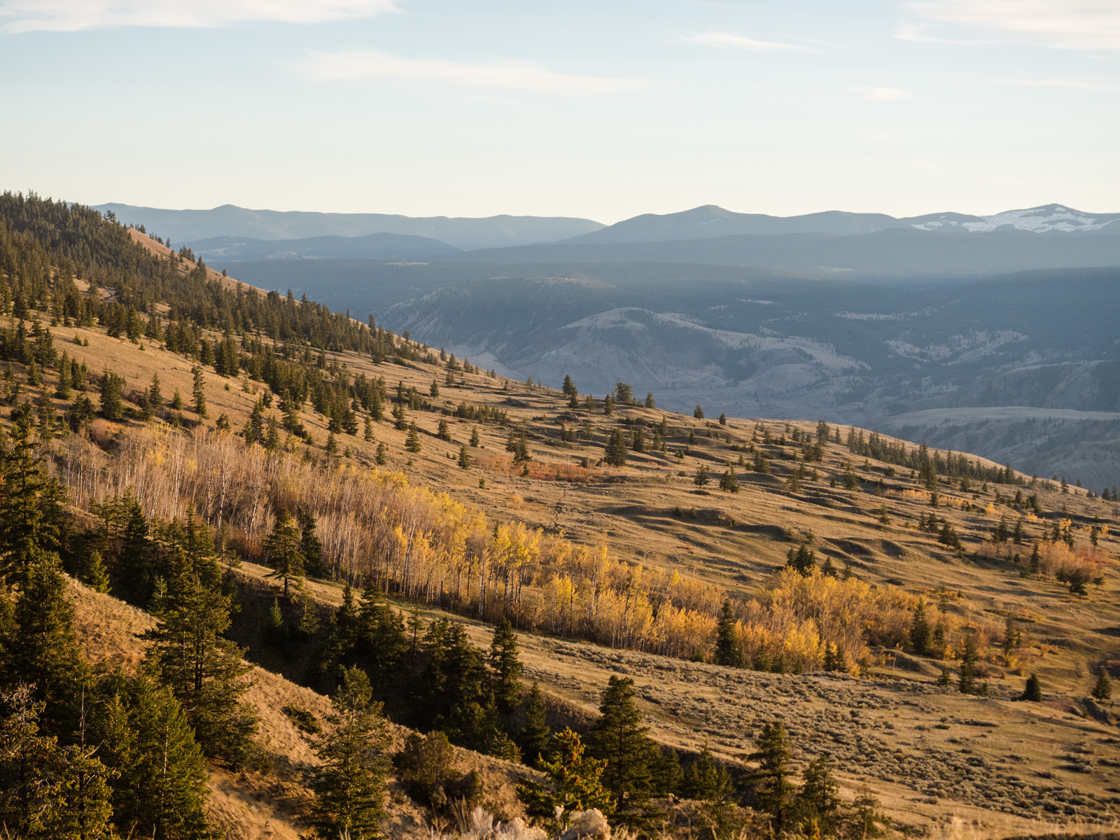
The final stretch runs from Downing Provincial Park and climbs to a pass, where you’ll be offered incredible views of the Coast Mountains. From there, it’s all downhill to Highway 99, which takes you back to Lillooet.


Camping, lodging, food, and water
There’s very little in the way of resupply on this route, particularly on the stretch from Lillooet to Williams Lake. You’ll want to carry enough food and fuel to get you between the two towns. On the way back there’s a small store at Alkali Lake and another at Dog Creek, not long before the Gang Ranch Bridge. I wouldn’t rely on these for meals, but they are reliable for snacks and drinks.
There’s a few creeks you can filter from on the West Pavillion Road. There’s a tap outside the ferryman’s house at Big Bar. On the east side of the river, there’s fewer accessible natural water sources, especially in summer and fall. There was a tap along the Big Bar Ferry Road just before you reach the Jesmond Road. Beyond that, you may need to ask some of the ranches for water if you’re running low. I was able to get water from someone at Canoe Creek. The Fraser River is very brown, so I wouldn’t get water from there, but I did filter water from the Chilcotin River.
There’s lots of wild camping options along the West Pavilion Road. On the east side of the river, there’s a lot more private property, making wild camping more challenging. Williams Lake has a bunch of hotels and is a good place to resupply before the return journey. The only official campsites along the route are at Desous Mountain just outside Williams Lake, and Downing Provincial Park. There’s a few guest ranches along the route that are marked on Google Maps.
The only bike shops along the route are in Williams Lake.
Which Bike?
Most of this route is on well-maintained gravel roads, so a gravel bike with at least 40 mm tires is sufficient. The only exception is if it is wet, in which case the roads can get muddy and you’ll want fatter tires.
Must Know
When to ride & weather
This route is best ridden in spring and fall, as temperatures can exceed 40 degrees in the canyon in summer. I expect it would be snow free by mid-May at the latest, and snow will come again in late-October or November.
Where to start?
Lillooet is the natural starting point and is about 3.5-4 hours drive from Vancouver. I parked at the Reynolds Hotel, though it wasn’t busy at the time and you may need to ask around if it is full. If you’re coming from the north, you can start in Williams Lake.
Time and suggested itinerary
This is a challenging route with over 10,000m of climbing in about 550km. I suggest taking eight days to ride the full route, including driving to and from the start. Here’s my suggested itinerary:
- Day 1 – Drive to Lillloet and camp along the West Pavillion Road
- Day 2 – Ride to Big Bar Ferry and camp
- Day 3 – Big Bar Ferry to Gang Ranch Bridge
- Day 4 – Gang Ranch to Farwell Canyon
- Day 5 – Farwell Canyon to Williams Lake
- Day 6 – Williams Lake to Gang Ranch Bridge
- Day 7 – Gang Ranch Bridge to Downing Provincial Park
- Day 8 – Downing to Lilloet and drive home.


Leave a Reply