

AKA, Cotahuasai-Colca Explorer
The Peruvian Andes is arguably the greatest bikepacking destination in the world. A sprawling network of dirt roads connects together the vast folds of the Andes Mountains. It is home to some of the highest mountains and deepest canyons in the Americas. The views are consistently spectacular, Quechua culture is rich in history and tradition, wild camping opportunities are abundant, and frequent small villages make resupply fairly simple. It is a country where you can point your bike in any direction and enjoy an incredible ride.
Most bikepackers in Peru follow a few established routes: The Huascaran Circuit through the Cordillera Blanca, and the Peru Great Divide, which connects the Cordillera Blanca with the Incan heartland near Cusco. From there, most travellers head to Cusco, while others follow the Cones & Canyons route to Arequipa.
This route provides an alternative way through the southern part of the country, linking the historic city of Ayacucho with the colonial gem of Arequipa. This is a spectacular part of the country, where a broad plateau is broken up by numerous canyons, including the two deepest in the Americas. The complete route is about 1,400 kilometres, with 31,000 m of elevation gain. I broke it into two parts for the purpose of this guide.
Part one starts in Ayacucho and ends in large town of Challuanca, where you can easily veer off to Cusco if that’s your destination. Part 2 continues onward to Arequipa through Cotahuasi Canyon, Valle de los Volcanes, and Colca Canyon.
Highlights:
- Cycling remote roads on the high plateau above Cotahuasi Canyon
- The approach to Huarcaya, an isolated village in an incredible location
- Riding 130 km from 4,800m down to 1,600m through the length of Cotahuasi Canyon
- The rugged beauty of the Vallee de Los Volcanes
- Crossing Rio Colca at the bottom of Colca Canyon at an altitude of only 1,400m.
- Catching site of condors in Cotahuasi and Colca canyons
- Entering Arequipa through the gateway of Chachani and Misti volcanoes
- Enjoying the delights of Arequipa after a hard ride through Peru.
Background
I rode this route in October and November of 2025. This is the start of the rainy season in Peru and I chose this route because the rain generally starts a bit later on the western side of the Andes, compared to the Cusco area. I started in Ayacucho because it had an airport and was near where I finished my 2018 trip. I wanted a trip that would take about a month and would finish in Arequipa, while passing through Cotahuasi and Colca canyons.
The route is broken into two parts for the purpose of this guide. Part 1 is an alternative to the Peru Divide, for those looking to get off the standard bikepacking routes and explore seldom-visited parts of Ayacucho District. Part 2 follows parts of Cones & Canyons, but has a different start and branches off to ride through Colca Canyon, which only became possible when a bridge was installed at the bottom of the canyon in 2019.
Route Map
WordPress won’t let me embed the route map from Ride With GPS, so click on the image instead.

Key stats:
- Distance: 770 km
- Elevation: 17,750 m
- Suggested riding time: 14-18 days, including rest days
- Road surfaces: 60% unpaved
Route Guide
Part 1 of this route begins in Ayacucho. Part 2 starts in Challuanca, a large town located on the main highway that connects Nazca, on the coast, to Cusco. Buses plying the road to and from Cusco stop here, so it is easy to access. It is about 20km south on Highway 30A from the end of the Peru Great Divide, so if you ride that route to the end rather than Part 1 (you’re missing out if you skip Part 1), you can easily pick up the route here. Alternately, you can start in Arequipa and ride the route south to north. Arequipa is a major city with frequent flights to Lima and Cusco.
Section 1: Challuanca to Quechualla
The first 15 km of this route follows the moderately busy Highway 30A until the turnoff to AP 109. Here, you’ll start a gradual 40 km climb to Paso Yanaquilca at 4,477m. Enjoy the oxygen in the valley, because from this point, you’ll stay above 4,400m for the next 130 km.
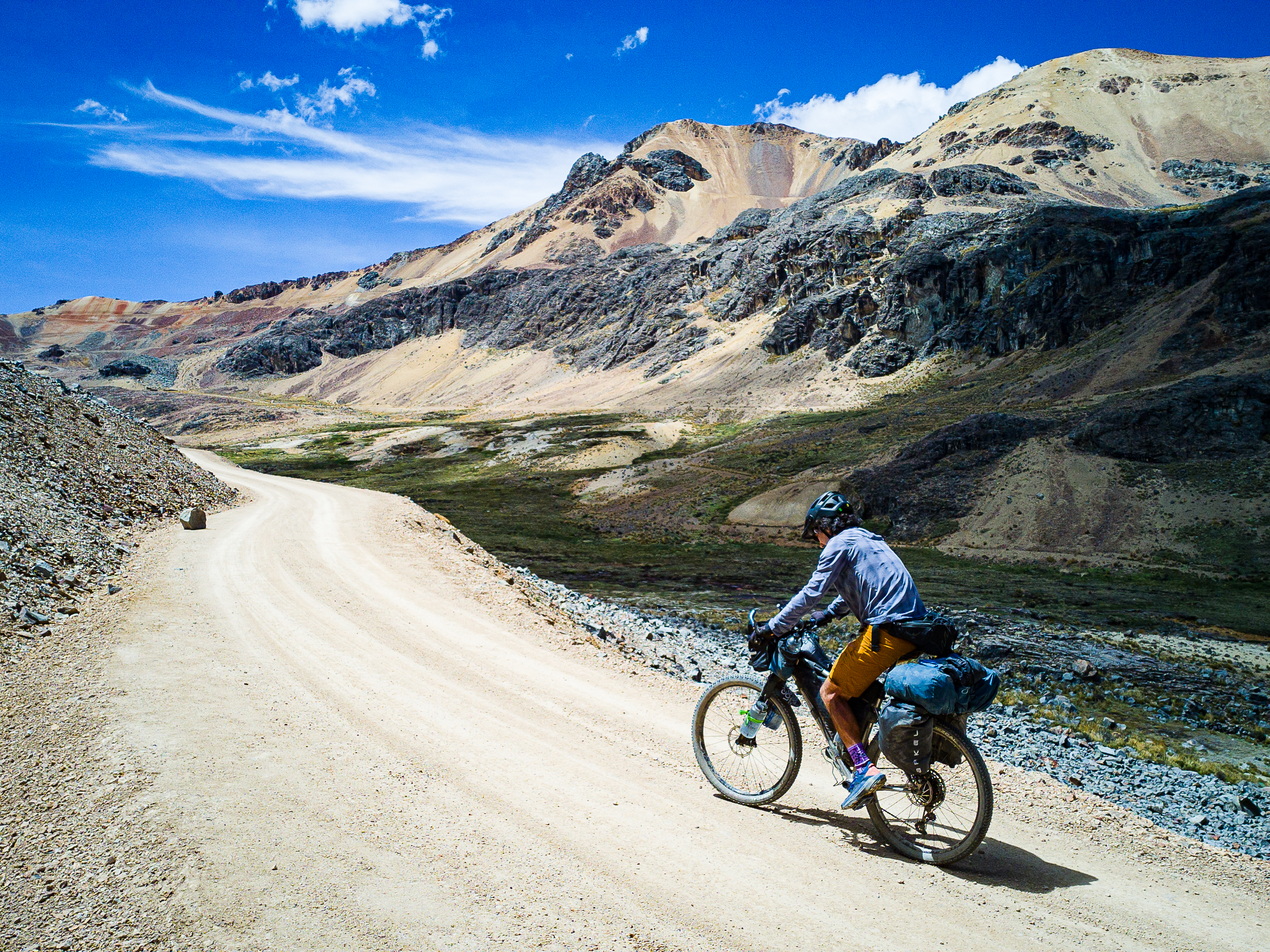
At the pass, the route turns south onto a rough and tumble dirt road. The first 10 or so kilometres are very rocky and challenging. Eventually, you’ll drop into a small valley and past a farmhouse. From there, the road improves drastically and the rest of the way is relatively smooth sailing. The route ebbs and flows up and down on the high plateau, affording views of mineral-rich mountains. You’ll pass by a few farm houses and herds of alpaca, but not much else.
After 60 km, you’ll end up on AP 111, where the silence is ended by the rumble of mining trucks. The plateau above Cotahuasi Canyon is home to several major mines, and this is the main access road. On the plus side, it means the road is well maintained and travel is quick. After 35 km, the mining traffic branches south, but the route continues straight into a beautiful valley that opens up Huarcaya. The village sits in a spectacular location, in a broad valley dominated by steep cliffs on either side. I was able to stay at the health clinic and there is a decently stocked store here, too.
Out of Huarcaya, the route heads south down a very scenic and little-trafficked road. There’s a sign for some hot springs just south of the village, but I didn’t check them out. You’ll pedal past herds of llama and alpaca and slowly climb along the flanks of a beautiful valley to 4,800m. From here, you’ll begin the long descent into Cotahuasi Canyon.
Cotahuasi is the deepest canyon in the Americas and the road bottoms out in the village of Quechualla at only 1,600m, but you’ll climb over 2,300m and descend 5,500m over 120 km to reach the bottom. Along the way, you’ll pass through Andean terraces, under towering cliffs, and through quaint villages. At one point, the canyon narrows so much that you’re force to climb 550m to get past the chokepoint. The town of Cotahuasi is the heart of the canyon, but the route continues further, into the barren depths at Quechualla. This road is a marvel of construction, as it hugs the sheer canyon walls before dropping down to the river for the final stretch. Quechualla is an oasis of fruit trees and grape vines. There’s a clean guesthouse here and the owner prepares great food. There’s a bus to Cotahuasi every morning and you can strap your bike to the roof to avoid the climb back to Cotahuasi, if you’d like. You may prefer to ride your bike rather than take the bus up that harrowing road.
Cotahuasi is a charming town that sees some tourism but isn’t that busy. There’s a decent selection of hotels and restaurants, and you’ll be able to stock up on food for the next stretch.


Section 2: Cotahuasi to Huambo
From Cotahuasi, it’s all uphill back to the alpine on a nice paved road. With 2,000m of elevation gain over 40 km, it’s not overly steep, but it is long. Enjoy the views of the Canyon as you climb; you may even see some condors higher up. When you gain the alpine, you’ll get up close to Vocan Solimana. The road continues through the puna, heading towards Volcan Coropuna – one of the highest moutains in Peru.
Eventually, you’ll turn off the highway onto a dirt road that wraps around the base of Coropuna. The volcano provides an incredible backdrop for what I found a very tough stretch of riding. The road climbs only 500m over 35 km, but it is consistently washboarded, making for a frustrating pedal. The suffering ends with a descent on potholed-pavement to Andagua in the heart of the Vallee de los Volcanes.
The Valley of Volcanoes is home to over 30 volcanic cones, while black lava flows are surrounded by lush green agricultural terraces. It’s worth spending some time here to enjoy the scenery and go for a hike. Don’t miss Catarata Sankillay, where several waterfalls pour out of the cliffs only a few kilometres from Andagua.
Out of Andagua, a paved descent past abandoned terraces brings you to the village of Ayo. Like Quechualla, Ayo is an oasis in an otherwise barren landscape. The road turns to dirt here and continues dropping to the bottom of Colca Canyon, at only 1,400 m. Locals recommend riding through the canyon in the morning because afternoon winds can result in rockfall. Fortunately, Ayo is home to a nice guesthouse and the warm climate makes for a pleasant stop.
The bottom of Colca Canyon is a dark place in the morning. The road drops dramatically downwards before crossing a small bridge at the confluence of two rivers. From here, you’ll begin a 2,800m climb over only 48 km. There’s very little water on the climb, so make sure you’re stocked up. Slowly, you’ll leave the desert depths of the canyon and emerge into the agricultural highlands near Huambo. The village comes after 2,000m of climbing and you’ll probably want to stop here rather than continue higher. Huambo has a couple of basic guesthouses, as well as some shops and restaurants.


Section 3: Huambo to Arequipa
Reaching Huambo, the hard riding is over. That’s not to say the rest of the way is easy – there’s still over 4,000m of climbing in the final 245 km – but the vast majority of it is paved and there’s no intensely steep climbs. The biggest shock just might be encountering the first stretch of mass tourism of the route as you enter the well-travelled heart of the Colca Canyon.
Leaving Huambo, you’ll complete the climb from the bottom of the Colca Canyon, topping out at about 4,030m. The views of the peaks on the north side of the canyon are incredible, but you can’t see into it quite yet. From the pass, you’ll drop down 800m, then begin a gradual climb through the town of Cabanaconde. It is the first touristy town you’ll pass and a great place to re-supply.
After Cabanaconde, you’ll keep climbing and eventually arrive at the first of several condor viewpoints. These majestic birds are easiest to see in the morning, but you will have to jostle for space with the hordes of tourists that show up to watch them in flight. The bonus is the views of the Colca Canyon and the river around 1,200m below. As you continue roughly eastward, you’ll pass by a few quaint Quechua villages. Finally, you’ll arrive in Chivay, which is the tourist centre of the canyon. It’s a lively town with some pretty good restaurants (I highly recommend Polleria Tiznao), a lively market, and nearby hot springs.
From Chivay, it’s a 1,300m climb back to the windswept puna. It’s not a hard climb, but it is long. When you reach the plateau, the winds will likely be your biggest challenge. If you’re lucky, you’ll get a tail wind, but you may also get walloped from the front or side. The positive is that it’s mostly downhill from the high point at Mirador de Los Andes. You’ll stay on the highway until the junction with 34A, where there’s a bunch of shops and restaurants, and even a hospedaje. Stock up on water here, because the next 45-50 km are dry until you reach Arequipa.
The final stretch of the route is quite simply majestic, You’ll leave the highway for a dirt road that cuts between Volcan Chachani (6,025m) an the conical El Misti (5,822m). While the road is quite sandy, it’s more than made up for by the views and the whimsical vicuna you’ll share the plateau with. Finally, it’s time for the 1,900m descent into Arequipa. This road was under construction when I rode it in Nov. 2025, which made for some very challenging conditions. If it’s been fixed, enjoy the splendid descent into the city. I found Arequipa to be a wonderful place to end the ride. The climate is perfect, there’s endless great food, and strolling the historic centre and into neighbouring Yanahaura is a great way to spend a few days.


Camping, lodging, food, and water
The first section of this route, from Challuanca to Cotahuasi, is the most remote, with only a few small villages in between, so carry lots of food and be prepared to camp every night. Fortunately, it’s not hard to find a scenic campsite on the puna. Huarcaya has a small store and you may be able to sleep at the health clinic if it’s open. Once you reach Cotahuasi canyon, you’ll pass through a few villages with small shops and even a guesthouse or two. Cotahuasi, the town, has everything you need to keep going. There’s nowhere to resupply between Cotahuasi and Andagua. After Andagua, you’ll find food and accommodation in Ayo, Huambo, and throughout the Colca Canyon.
Water is found fairly frequently along the route, but you’ll definitely want to filter it. The driest stretch is on the climb out of the Colca Canyon to Huambo, so you’ll want to leave Ayo fully loaded. You may be able to hike down to the river near the bridge about 1,000m into the climb. Otherwise, the first easily accessible water source is 21 km and 1,400m above the canyon floor. If you’re starting in Arequipa, you’ll want to start with lots of liquid since there’s no water for the first 60 km of climbing out of the city.
For cooking, I used an alcohol stove and found 96% alcohol in Challuanca, Cotahuasi, Cabanaconde, and Chivay. It’s easiest to find in a dedicated farmacia, but can be bought in general stores elsewhere.
Which Bike?
Given some of the rough roads, a rigid mountain bike with 2.25″ tires is recommended at minimum. Front suspension is a bonus and you’ll really appreciate it on the gravel road connecting Cotahuasi and Andagua.
Must Know
When to ride & weather
The rainy season in Peru is said to run from October to April, with the worst months generally being January through March. I rode this route from Oct. 21 to Nov. 23, 2025, and had generally fantastic weather throughout, but also probably got a little lucky with the unexpected dry spell. I did get caught in a hail/thunderstorm on the approach to Cotahuasi, which was pretty terrifying. Fortunately, it was the only bad weather I experienced all month. One thing that was consistent was the winds, which would pick up in the afternoon and inevitably died off at sunset. I never had to deal with a windy campsite. It can get below freezing at night above 4,000m, especially if you’re riding in the dry season.
Where to start?
I rode the route from north to south, but there’s no real reason you couldn’t go the other way and start in Arequipa. The benefit to finishing your ride in Arequipa is that it’s a fantastic city to unwind in after some tough stretches on the bike.
Part 1 of this route ends in Challuanca, which is on the main highway that links Cusco to the coast. Regular buses will take you from here to Cusco or Lima.
Time and suggested itinerary
I rode this section in 16 days, including two rest days in Cotahuasai and one in Chivay. I wouldn’t want to have gone any faster, but definitely could have gone a little slower. Expect to do at least 1,000m of climbing every day, and to have some days with over 1,500m, and even up to 2,000m.


Leave a Reply