

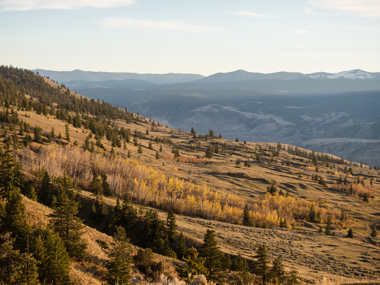
“El Silencio” – what Peruvians call the high altitude regions of the country where few venture and only the hardiest make a living. It’s a land of towering mountains, grassy valleys, azure lakes, hardscrabble herders and their flocks, and, unfortunately, massive mines that scar an otherwise beautiful landscape.

I had seen pictures of these landscapes while planning my trip and I was excited to finally reach this part of Peru, where I’d leave everyone behind and be practically alone. Just to be safe, I sent my brother a GPS of my route for the next few days knowing I was about to enter a remote area with few people around in case things go wrong.
I was up early to set off from Huamachuco towards “El Silencio.” After a hearty soup at the market for breakfast (and a cup of some unknown local gloop I decided to try for the first and last time), I pedaled off on the highway out of town. I could follow it to the Cordillera Blanca, or I could go the long way.
After 10 kilometres of highway riding, where I got my first look of one of the big mountain-top mines that dot Peru, I turned off onto a dirt road and gradually began to rise above the farms, into the beyond. I stopped to eat lunch at a beautiful lake, where locals had a trout farm. Once past that settlement, I truly felt on my own. For the rest of the day, I passed one group of road workers and that was it.


The road wound through a valley, then into another punctuated by blue lakes that were dominated by dark, craggy peaks. The road snaked through the lakes and crested a ridge before easing its way ever upwards, towards a height of some 4,400 metres and staying there.


This stretch of road was a ribbon blasted along a steep mountainside, and as it got dark, I looked for a place to camp. The clouds moved in, darkening the sky even further. Through the fog, I could barely make out the terrain around me. I spotted a lone house below the road but didn’t stop. As I began to lose hope, I spotted a pond through the midst, with enough of a flat spot next to it for my tent. A light rain fell and the wind howled as I scrambled to set up camp before getting soaked. Tent secure, I huddled inside and changed into warm clothes. I got ready to cook dinner only to find neither of my lighters working. After several moments of frustration, I finally got a whiff of flame – just enough to light up my stove – and cooked up a simple dish of rice, veggies and tuna. When I emerged to wash my dishes, the sky had cleared up and I was dazzled by a brilliant starry sky.


The next morning was overcast but dry. My lighters wouldn’t spark so I delved into my snack supply for breakfast and made a mental note to get to a town and buy more matches and more lighters. My route this morning stayed above 4,000 metres, an elevation I was reasonably comfortable at by now. Dark green, brown, yellow and grey scenes unfolded and as I rounded a corner, I came across a herd of alpaca. They were everywhere, their strange faces eyeing me with curiosity. Some kept grazing, others ran off, and all were wonderful to watch in their natural habitat. The herd was vast and stretched through the puna, with more appearing after every switchback.


Saying goodbye to my four-legged friends, I cruised down to a river crossing where a few hardy farmers were sawing up some wood. From there began a 500 metre climb above a startlingly green river valley with almost no signs of human encroachment except for a few livestock and two women walking down from the hills. I gazed across at bright green lake that sat below a jagged cliff face as I neared the final pass of the day and the skies darkened.


At the pass, the light drizzle turned into rain, which turned into a downpour, which turned into a snowstorm as I descended. Not wanting to stop to put on my warm jacket, I had a frigid ride to Laguna Pelagatos some 600 metres below. My rain jacket and t-shirt were no match for the biting wind and near-freezing temperatures and by the time I reached the lake, I was shivering. I saw a sign saying “cocina” (kitchen) and ran in the open door where I was greeted by a friendly woman who asked me where I had come from. When I explained my route, she said two other cyclists had passed through that way before, but there had been none for a few years. She warmed up some rice, potatoes and a bit of meat and boiled up some tea. I placed my soaking wet socks and gloves on her wood stove and attempted to dry out my shoes.


An hour later, with the rain stopped and myself a little warmer and drier, I left the comfy confines of the kitchen for the descent to Pampas, where I decided I’d find a cheap hotel for the night. I followed yet another dramatic road through a half-forgotten mining town where a few people still lived among the rusty, abandoned buildings.


I arrived in Pampas a little warmer and found a cheap hotel that let me drag in my muddy bike and self. A hot shower and some food, and I was off to bed, eagerly anticipating my next adventure along a route I’d mapped out while gazing at Google satellite images a few days earlier. The route would take me back to the alpine along a series of roads and trails, over a 4,400 metre pass and past a chain of alpine lakes. Or at least that’s what I hoped it would do. The elevation profile showed some steep sections, but nothing that couldn’t be pushed, I hoped. That would be followed by another lengthy stretch through the puna to a town called Corongo. Then I would descend into the Canon del Pato – a section of Peru’s main Andean “highway” that runs through some 30+ tunnels blasted into a canyon wall – and follow that to Caraz, the northernmost city in Peru’s Cordillera Blanca.

The route started with a steep series of switchbacks out of Pampas, followed by a descent then a short climb into Conchucos, where I had delicious roast beef for lunch. My rule of going to the busiest restaurant paid off.


From Conchucos, my route involved 20 kilometres of unknown terrain until I’d hit the next known road. I stocked up on food in, thinking I could make it in two days, but preparing for three just in case. And I found the Internet to message my brother so he could send out a search party if necessary.
I hit the road south out of town and turned onto a pedestrian bridge over a creek, where I had to wait a few minutes for a shepherd to cross first. Almost right away, I realized my chosen route wouldn’t be as rideable as I hoped. The shepherd asked where I was going and when I told him, he scoffed and said the trail was too steep and hard. I replied that if it got too tough, I would turn back.

I started pushing, riding what few short sections I could. I garnered many surprised looks and a few more comments that I was nuts, but good luck. As I got closer to the puna, the trail steepened, and I was forced to take my panniers off my bike, carry them uphill, then return for my bike. I repeated this slow, tiring process multiple times until I found myself amidst the grassy fields of the puna, gazing out over huge mountains and far down into the valley I’d left hours earlier. I gazed at the ribbon of singletrack that cut its way through the mountains and looked very rideable.


I felt alone in the mountains, taking in the solitude of “El Silencio.” I was not expecting someone to come walking over the ridge to get cell reception. He was younger than most rural farmers and his home was just beyond where I rested. He confirmed my route made sense, but warned it was very rocky. I rode and pushed my bike towards his home when he came running up behind me, warning me of his dogs. As if on cue, four big hounds bounded towards me, snarling fiercely. The man attempted to call them away, but they were more interested in me. They gave chase, circling my bike as I kept to my usual strategy of ignoring the dogs until they get bored. When this didn’t work, I picked up a big rock. This got their attention and they backed off, finally heeding the calls of their owner.
At this point, it was nearing dark and I started looking for a place to sleep. Up ahead I saw what looked like a stone and grass hut. I pushed through a herd of cows to a small bench where some stone ruins stood. I peaked in the hut but the ground was uneven, the roof had holes, and it was too small to pitch my tent in. I found a spot to pitch my tent nearby as it started to rain. I hunkered down after spending four hours to go six kilometres.

The next morning I woke up to find a lot of cattle wandering around my tent, curious about this intruder on their land. I pushed my bike to the top of a small ridge to pick up the trail again, then rode and pushed it through the alpine. A few cows grazed in the distance and I could see one home on a distant mountainside but otherwise it was just me and the mountains.

My priority this morning was to find water as I was down to my last few drops. Fortunately it wasn’t too long before the trail crossed a creek that spilled out of an alpine lake and I could fill up my water bottles. Beyond the lake stood the 4,400 metre pass – only a few kilometres and 300 metres of climbing above. I figured I would be at the top by noon, down the other side by one and on the next road by two. I had yet to realize how hard a hike-a-bike could be at 4,000 metres.

The next section was the most challenging so far. The rocks were bigger and some sections of trail were so steep that I once again has to transport my gear in stages. I spent more than an hour to clear the first kilometre or so, at which point I stopped for lunch and cooked up some oatmeal. The views were incredible as I looked down on a pair of alpine lakes and the dark green alpine landscapes beyond. A ridge of black rocky mountains pierced the blue sky on my right. This was definitely type two fun.

I didn’t have far to go but the next stretch to the top of the pass was the hardest yet. I took my panniers up first, breathing heavily as I picked my way up the trail to the pass before returning for my bike. At the pass, I gazed down on the reason I chose this route – Las Lagunas Pusaccochas – a series of nine of alpine lakes stretching through a steep-walled valley. Dark clouds were moving in, making for an foreboding scene. Much to my chagrin, the trail down to the lakes was just as rocky as the one I’d come up, meaning I’d have to push some more.
“Never again,” I lied to myself, as I admired the view.

The push down was easier than going up, but much more frustrating. It also started raining, and while most of my rain gear was holding up, my shoe covers no longer did their job. At times the trail was essentially a creek and I gave up on trying to keep my feet dry. I reached the valley where instead of the flat trail I hoped for, it climbed up and down along the slopes above the lakes. I gazed at the lakes and waterfalls in between curses of frustration at the rugged terrain I was dragging my bike through. Sadly, my troublesome camera acted up again and most of the pictures I took were corrupted. I did take a few with my cellphone that capture the beauty of the area.


At this point I wasn’t so much physically tired as I was mentally exhausted from the day’s ordeal. I knew I could make it to the road, but frustration was mounting as I hauled my bike over one rock after another. As I passed between lakes two and three, I saw a cave across from my position. I went to inspect it and saw it was well used by locals. There was signs of fires, a bed of dry straw, and a bit of garbage scattered about. Most importantly, it was dry. I retrieved my gear and carried it over in several trips. I settled down, watching the rain fall quietly outside as I ate a simple meal of rice, veggies and tuna. I laid out my air mattress on the grass, crawled into my sleeping bag and read until I fell asleep. After a hard day, the cave was serene.

I still had a kilometre of pushing before I reached the road and it was just as hard as the previous day’s slog. I jumped for joy when I discovered the road began sooner than expected and I was able to bike the last stretch to the end of the last lake. After more than a 1.5 days of pushing, it felt so good to spin my legs again. I cruised into the valley beyond the lakes and turned onto the road to Corongo, where I passed some very surprised workers, who greeted me with friendly cries of “Gringo!”
The road to Corongo descended to 3,900 metres, crossed a creek and then climbed back up to a plateau at 4,400 metres. The weather mostly held off for the morning, but as I reached the plateau, rain and snow moved in. A herd of vicuna scampered across the road ahead of me and galloped away before I could get my camera out. I pedaled along the plateau, which was intersected by a maze of rough roads and small lakes. The only sign of civilization was a set of power lines and two lonely walls seemingly not ever part of a complete structure, their existence a mystery.
It was a cold, wet, and fairly miserable stretch. My feet were soaked, the road was muddy and it was slow going. At least I was able to pedal and there were no real climbs to be had. A herd of cattle scampered below me, but there was no signs of their owners. Were they wild?

Eventually I found my way to the descent to Corongo – a 20-kilometre, 1,200 metre downhill on massively rutted track. I picked my was down the mountain, using my best mountain biking skills to choose the smoothest way down. It was a blast, if not a little hairy at times as I zig-zagged over and around deep ruts. I gradually entered civilization again, first passing herds of sheep, then seeing another person for the first time in hours, then reaching a beautiful green valley and a small village that I cruised through quickly so I could reach Corongo and have a warm shower.
Corongo, as expected, was a quiet, brown village with not much going on. I chatted to a few men in the plaza, asking about a place to stay. All I really cared about was a hot shower, so one of them took me to the small hospedaje he ran. At 15 soles ($6 CDN), the price was right. I hung up my clothes and tent to dry and then went to eat at the local restaurant. When that didn’t satisfy me, I ate some street food, then bought a few chocolate bars. And I let my brother know I was safe and sound and he didn’t need to send out a search party.

My ride wasn’t over. After five tough days out of Huamachuco, I was ready for a break but Corongo wasn’t the place for it. There was nothing to do and no Wifi at the guesthouse so the next morning, after enjoying a great sandwich (it was so good I bought a second to go) and delicious juice for breakfast, I started the descent out of farming country and into the desert lowlands of the Peruvian Andes. Down and down I went, first on a dirt road, then on a one-laned paved road – the 3N that I’d left five days ago south of Huamacucho. The wind accelerated as I descended and on the final series of switchbacks I had to take care not to be blown off the road.


My descent ended at about 900 metres elevation – some 3,600 metres below where I was a day earlier. I then began the climb into the Canon del Pato (Duck Canyon) to the Cordillera Blanca, stopping to camp 40 kilometres shy of Caraz. It was hot in the canyon and I was able to strap my wet socks and gloves to the back of my bike and I slowly dried out. I generally don’t enjoy cycling in the heat but after the last few days I was grateful for the sun and to not having soaking wet feet all day.


The next morning I struggled to get moving on the final 40 kilometres up to Caraz. My route went through the numerous of tunnels of the Canon Del Pato that highway engineers blasted into the sides of the canyon walls because there really wasn’t anywhere else to put the road. Exhausted, the climb took forever and I considered hitchhiking, but eventually I made it and found myself a room for 15 soles at the Hostal San Marco. The room was basic but the wifi worked and the shower was reasonably warm. The main plaza was surrounded by bakeries selling borrachitos, these delicious chocolate balls that they should sell everywhere but don’t. I also had an email from Iohan, aka the Bike Wanderer, who I’d been in touch with a month prior and who I unexpectedly happened to have caught up with in Caraz.
We agreed to rest up and then ride through the Cordillera Blanca together along with his friend Sylvain, who was due to arrive from Quebec in two days.
After riding seven days in a row and 15 of 18 since Boxing Day, that worked for me.


Leave a Reply